Climate change has resulted in wetter winters and dryer, hotter summers on the West Coast, creating the dense and extremely flammable vegetation that contributed to the catastrophic forest fires accelerated by hazardous high winds in the last five years. The creators of the California Forest Observatory, which provides regularly updated high-resolution data on the drivers of the state’s wildfires, want to help land management and fire agencies better understand the fires and develop natural climate solutions such as increased use of prescribed burns and better, proactive forest management.
The online 3D map was launched in mid-September with the hopes of being a resource at the start of wildfire season. The creators were not expecting a record-breaking month of forest fires. Hundreds of user accounts already have been created for the platform, which is free and open for use by government agencies, researchers and nonprofit groups on the front lines.
“We want them to use it as much as possible and we want to support that use as much as possible,” says Kyle Gertridge (KSAS ’10), head of business development and partnerships for Salo Sciences, developer of the Forest Observatory.
Licenses are available for commercial users, and Gertridge acknowledges that making a pitch to a for-profit company for a new product focused on a catastrophe can be challenging.
“We’ve had to be really careful with the messaging around promoting the platform. The core mission is public benefit and it’s free for the people who need it,” he says.
San Francisco-based Salo Sciences, co-founded by David Marvin, Ph.D., (KSAS ’05), creates technology-based ecological solutions for clients. For example, it helps land managers plan forest restoration and utility companies manage vegetation to decrease fire risk.
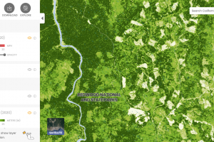
Salo collaborated with two other companies on the Forest Observatory. The idea was to create an easily updatable and more accurate version of certain aspects of LANDFIRE, a consortium-produced wildfire-vegetation-fuels dataset used to predict fire spread and risk. LANDFIRE data is produced at 90-feet resolution and currently only goes up to 2016, before three of the worst fire seasons in California’s history.
The Forest Observatory, by contrast, produces data at 9-feet resolution, meaning individual trees are visible. It can be updated yearly or quarterly depending on user needs. All of the data — including information about canopy height and cover and surface fuels, which contribute to fire behavior patterns — is based on remote sensing, artificial intelligence and algorithms that will continually improve with more input and larger areas, Gertridge says.
The Forest Observatory incorporates data from as far back as 2016, so users can track changes or mark trends over time. The map’s creators plan to update the site in December to show the impact of this year’s fires, Gertridge says.
“The goal is to commercialize the data for industry and find funding from state or federal sources to support ongoing updates to the data and keep it free and open for noncommercial use,” says Gertridge.
Gertridge took the job at Salo in part because of his Johns Hopkins connection with Marvin. Gertridge majored in economics and minored in entrepreneurship, both of which have come in handy, the former as he handles the company’s business side. The latter provided the “mile-wide, inch-deep” skill set he uses as part of a four-employee startup.
The Forest Observatory’s creators would like their map ultimately to cover North America, and they are eyeing other regions threatened by wildfire risk, such as Australia, which had its own record-breaking wildfire seasons recently.
“Anywhere there is a vested interest in better forest management and understanding forestlands better, we want the map to cover that,” says Gertridge. “We want to become the new standard for this type of forest vegetation data.”